Stockfarm Bridge
Campground · Wisconsin · 8 bookable sites ·
Managed by the USDA Forest Service
Chequamegon National Forest (NF) · Open Access
- 8
- Bookable sites
- up to 16
- People per site
- 8
- Accessible sites
- 1,463 ft
- Elevation
Overview
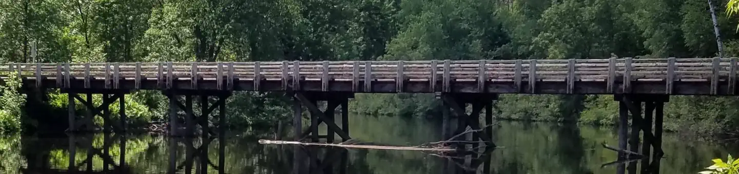
Stockfarm Bridge Campground is located in a red pine forest on the East Fork of the Chippewa River, a candidate wild and scenic river.
Recreation
Located on the edge of the elk capital of Wisconsin, the Stockfarm Bridge Campground area has activities for everyone. Miles of off-road vehicle on the Dead Horse Run Off-road Vehicle Trail (ATV/UTV), canoeing, kayaking, and fishing in the scenic East Fork of the Chippewa River or hunting during the fall small and big game hunting seasons.
Facilities
The campground offers 7 single family campsites and one group site accomodating up to 16 people. There is a hand-pump for potable drinking water, accessible vault toilets, fire rings and picnic tables. Trash collection and recycling bins are available at the campground as well.
Natural Features
The Chequamegon-Nicolet National Forest offers 845,000 acres of lush landscape dotted with lakes, rivers and streams. Pine, spruce, maple, aspen and balsam forests, as well as extensive jack pine plantations, make up the vegetation.
The facts
- Season: May 2 – October 31 — USDA Forest Service, Aug 24, 2026
- 8 bookable sites
- 8 accessible sites
- Up to 16 people per site
- Loops: A
Site types
- 7 Standard Nonelectric
- 1 Group Standard Nonelectric
Amenities
- Campfires allowed
- Shade
- Pets allowed
Not recorded upstream: electric hookups, water hookups, sewer hookups, fire pits, picnic tables, grills.
8 campsites at Stockfarm Bridge
| Site | Loop | Type | Entry | Surface | Grade | Water | Max rig | People | |
|---|---|---|---|---|---|---|---|---|---|
| 1 | A | Standard Nonelectric | Back In | Gravel | Slight | Riverfront | — | 8 | ♿ 🐾 |
| 2 | A | Standard Nonelectric | Back In | Gravel | Slight | Riverfront | — | 8 | ♿ 🐾 |
| 3 | A | Standard Nonelectric | Back In | Gravel | Slight | Riverfront | — | 8 | ♿ 🐾 |
| 4 | A | Standard Nonelectric | Back In | Gravel | Slight | Riverfront | — | 8 | ♿ 🐾 |
| 5 | A | Standard Nonelectric | Back In | Gravel | Slight | Riverfront | — | 8 | ♿ 🐾 |
| 6 | A | Standard Nonelectric | Back In | Gravel | Slight | — | — | 8 | ♿ 🐾 |
| 7 | A | Standard Nonelectric | Back In | Gravel | Slight | — | — | 8 | ♿ 🐾 |
| 8 | A | Group Standard Nonelectric | Back In | Gravel | Slight | — | — | 16 | ♿ 🐾 |
Getting there
From Loretta, drive north on County Highway GG 10.8 miles to the intersection of FR 164. Turn right (east) and drive 7.8 miles to the campground.
From Glidden, drive south 9.4 miles on Highway 13 to Bear Lake Road (FR 163). Turn right (west) on Bear Lake Road and drive 9 miles to FR 164. Turn right (north) on FR 164 and drive 3 miles to the campground.
46.03794, -90.71433 · 46°2'16.6"N 90°42'51.6"W
Typical weather
| Jan | Feb | Mar | Apr | May | Jun | Jul | Aug | Sep | Oct | Nov | Dec | |
|---|---|---|---|---|---|---|---|---|---|---|---|---|
| High °F | — | — | — | — | — | — | — | — | — | — | — | — |
| Low °F | — | — | — | — | — | — | — | — | — | — | — | — |
| Precip in | 1.2 | 1.1 | 1.9 | 3.0 | 3.8 | 4.4 | 4.3 | 3.8 | 3.6 | 3.4 | 2.1 | 1.6 |
1991–2020 averages from the nearest NOAA station, 7.5 mi away — not measured at the facility itself, and elevation can make a real difference over that distance.
Map
More photos

Member photos
Common questions about Stockfarm Bridge
- Can you reserve a site at Stockfarm Bridge?
- Yes, Stockfarm Bridge is reservable through Recreation.gov.
- How many campsites does Stockfarm Bridge have?
- 8 sites.
- Are pets allowed at Stockfarm Bridge?
- Yes, pets are allowed at Stockfarm Bridge.
- Are campfires allowed at Stockfarm Bridge?
- Campfires are allowed at Stockfarm Bridge. Check for a current fire restriction before you go.
Also listed by
Stockfarm Bridge also appears in other federal recreation data. Facts below are matched by name and location, not confirmed by Stockfarm Bridge's operator.
USDA Forest Service — data as of Aug 24, 2026
- Individual campsite fee is $15, or $7.50 with the use of an Interagency pass (access or senior). The interagency pass applies only to the fee for the campsite physically occupied by the pass holder, not to any additional fees or campsite(s) occupied by members of the pass holder's party. The group c
Restrictions:
- Maximum of 8 people and 4 vehicles at each camp site.
- Vehicle capacity limit includes vehicles, wheeled camping units and trailers.
- Pets must always be restrained or on a leash while in developed recreation areas.
- Pets (except guide dogs) are not allowed in swimming areas.
- Saddle or pack animals are allowed in recreation sites only where authorized by posted instructions.
- Our firewood closure order prohibits the possession, storage, or transport of any firewood that originates from more than 25 miles from your campsite. Firewood certified by the Wisconsin Department of Agriculture, Transportation and Consumer Protection can originate from more than 25 miles from Nati
- Both certified firewood and Kiln-dried, untreated/unpainted/unstained/construction/dimensional lumber that is free of any metal or foreign substance is approved. Pallet boards are not approved.
Camping near Stockfarm Bridge
- Black Lake 11.2 mi · Campground · we watch it
- East Twin 12.7 mi · Campground · we watch it
- Day Lake 13.4 mi · Campground · we watch it
- Moose Lake 14.8 mi · Campground · we watch it
- Mineral Lake 18.3 mi · Campground · we watch it
- Beaver Lake (Chequamegon-Nicolet NF, WI) 19.8 mi · Campground · we watch it
- Lake Three 20.6 mi · Campground · we watch it
- Namekagon 23.8 mi · Campground · we watch it
- Sailor Lake 24.9 mi · Campground · we watch it
- Great Divide District 9.5 mi · Facility
- Beaver Lake Recreation Area 20.2 mi · Campground
- Namekagon Lake Recreation Area 22.8 mi · Campground
Contact
Recreation.gov last updated this record on 2026-02-25.
Facility information and photographs from Recreation.gov (RIDB). SpotOpened is not affiliated with Recreation.gov or any federal agency.
Comments