Clear Lake Group Site
Campground · Washington · 1 bookable site ·
Managed by the USDA Forest Service
Snoqualmie National Forest (NF) · Open Access
- 1
- Bookable site
- 30 ft
- Max rig length
- up to 40
- People per site
- 2,958 ft
- Elevation
Overview
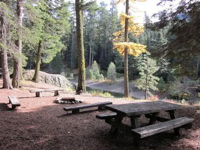
Clear Lake Group Campground is along the North Fork of the Tieton River in the Okanogan-Wenatchee National Forest.The campground sits between popular Rimrock Lake and the quieter Clear Lake beneath a canopy of towering pine and fir trees. Perched on a rocky bluff overlooking the area, this secluded spot offers access to a variety of recreational opportunities.
It is an ideal setting for large family and group gatherings.
Recreation
Clear Lake Group Campground offers outdoor enthusiasts the opportunity to hike, fish, ski, raft and enjoy a multitude of outdoor recreational activities throughout the year. Visitors enjoy the nearby Rimrock Lake for its myriad of water activities, including fishing for kokanee salmon or trout and kayaking along the shore. River enthusiasts may enjoy a whitewater rafting trip on one of the many scenic rivers in the area. The Tieton River is especially exciting in September, when the Bureau of Reclamation floods the Tieton Valley. The river is perfect for river enthusiasts seeking the thrill of whitewater.Facilities
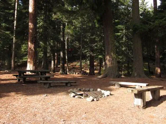
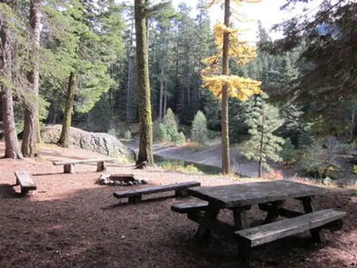
Clear Lake Group Campground is a single group site that can accommodate 40 guests. The parking area can hold about ten cars or five RVs and provides walk-in access to a large tent camping area. The site is equipped with picnic tables, accessible vault toilets and a group campfire ring.Natural Features
Okanogan-Wenatchee National Forest offers stunning scenic views, with high, glaciated alpine peaks, valleys of old growth forest and rugged shrub-steppe country making up the diverse landscape. Elevations range from below 1,000 feet to more than 9,000 feet. Visitors can expect many days of warm, sunny weather in the summer, and winters with clear skies and plenty of snow. The Tieton River, adjacent to Clear Lake Group Campground, is a tributary of the Naches River. Its headwaters originate in Goat Rocks Wilderness, collecting water from snow melt and glaciers in high rugged peaks. These peaks are remnants of an extinct volcano, taking the name "Goat Rocks," in honor of the mountain goats traversing this isolated region.
Nearby Attractions
A boat ramp is available within 10 miles of the campground.
Visitors enjoy Mt. Rainer National Park, where interpretive programs and exhibits offer education about the diverse landscape and history of the area. The spectacular Pacific Crest Trail (PCT), one of the world's premier National Scenic Trails, showcases some of North America's most fantastic scenery, winding its way its way from Mexico to Canada through California, Oregon and Washington, and is accessible near the campground.
The facts
- 1 bookable site
- Vehicles up to 30 ft
- Up to 40 people per site
- Loops: AREA CLEAR LAKE GROUP SITE
Site types
- 1 Group Standard Area Nonelectric
Amenities
- Fire pits
- Picnic tables
- Shade
Not recorded upstream: electric hookups, water hookups, sewer hookups, campfires allowed, grills, pets allowed.
1 campsite at Clear Lake Group Site
Check-in 1:00 PM · Check-out 11:00 AM
| Site | Loop | Type | Entry | Surface | Max rig | People | |
|---|---|---|---|---|---|---|---|
| 001 | AREA CLEAR LAKE GROUP SITE | Group Standard Area Nonelectric | Pull Through | Gravel | 30 ft | 40 |
Getting there
From Naches, follow Highway 12 west for approximately 34 miles to County Road 1200/Tieton Reservoir Road at the west end of Rimrock Lake. Turn south/left on County Road 1200 and follow for about .3 miles to Road 740. Continue for a half-mile, and the reservation site is the second campsite on the left along the North Fork Tieton River.
From Packwood, follow Highway 12 east approximately 27 miles to County Road 1200/Tieton Reservoir Road. Turn south/right on County Road 1200 and follow for about .3 miles to Road 740. Continue for a half-mile, and the reservation site is the second campsite on the left along the North Fork Tieton River.
46.63148, -121.26793 · 46°37'53.3"N 121°16'4.6"W
Typical weather
| Jan | Feb | Mar | Apr | May | Jun | Jul | Aug | Sep | Oct | Nov | Dec | |
|---|---|---|---|---|---|---|---|---|---|---|---|---|
| High °F | — | — | — | — | — | — | — | — | — | — | — | — |
| Low °F | — | — | — | — | — | — | — | — | — | — | — | — |
| Precip in | 7.8 | 5.3 | 5.0 | 2.6 | 1.8 | 1.1 | 0.3 | 0.5 | 1.4 | 4.2 | 6.9 | 8.4 |
1991–2020 averages from the nearest NOAA station, 5.3 mi away — not measured at the facility itself, and elevation can make a real difference over that distance.
Map
More photos
Member photos
Common questions about Clear Lake Group Site
- Can you reserve a site at Clear Lake Group Site?
- Yes, Clear Lake Group Site is reservable through Recreation.gov.
- How many campsites does Clear Lake Group Site have?
- 1 site.
- What is the maximum RV length at Clear Lake Group Site?
- 30 ft. That is the longest vehicle the sites here are recorded as taking; individual sites may be shorter.
Also listed by
Clear Lake Group Site also appears in other federal recreation data. Facts below are matched by name and location, not confirmed by Clear Lake Group Site's operator.
USDA Forest Service — data as of Aug 24, 2026
- Daily Fee - $60.00
Restrictions:
- Maximum 40 people and 10 vehicles.
Accessibility:
- See video
Camping near Clear Lake Group Site
- Indian Creek Campground (WA) 1.5 mi · Campground · we watch it
- South Fork Group Site - Wenatchee NF (WA) 6.6 mi · Campground · we watch it
- Indian Creek Recreation Area Campground 0.7 mi · Campground
- Horseshoe Cove Boat Launch 3.2 mi · Facility
- South Fork Tieton Dispersed Camping 3.6 mi · Campground
- Dog Lake Day Use/Boat Launch/Trailhead 4.7 mi · Facility
- Dog Lake Campground 4.7 mi · Campground
- White Pass Lake (Leech Lake) Campground 5.6 mi · Campground
- Peninsula Campground 6.2 mi · Campground
- South Fork Bay Campground 6.5 mi · Campground
- South Fork Group Campground 6.5 mi · Campground
- Deep Creek Trailhead - Naches RD 9.4 mi · Campground
Contact
- Phone (509) 653-1401
- Book Recreation.gov
Recreation.gov last updated this record on 2026-03-11.
Facility information and photographs from Recreation.gov (RIDB). SpotOpened is not affiliated with Recreation.gov or any federal agency.
Comments