Townshend Lake Recreation Area
Campground · Vermont · 3 bookable sites ·
Managed by the US Army Corps of Engineers
Townshend Recreation Area (Recreation Area) · Open Access
- 3
- Bookable sites
- up to 100
- People per site
- 3
- Accessible sites
- 523 ft
- Elevation

Overview
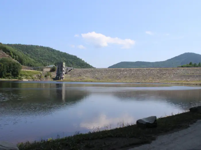
Townshend Lake is a flood control project operated by the U.S. Army Corps of Engineers, serving communities within the West River Valley, and those downstream. In addition to protection from floods, the lake provides many recreational opportunities, including picnicking, hiking, and fishing.
Recreation
Townshend Lake offers ample recreation opportunities. A boat ramp provides access for canoeing, kayaking and small motor boats (10hp or less). The lake is stocked once a year with Rainbow Trout for the enjoyment of anglers. The three group shelters are surrounded by many individual picnic tables with charcoal grills for smaller groups to enjoy. The Ledges Overlook Trail offers stunning views of the Green Mountains along the 1.7 mile loop, with Townshend Lake Nature Area a short drive north up Route 30 offering access to the West River Trail.
Facilities
Within the Townshend Lake Recreation Area, three large picnic shelters are available for reservation, each equipped with electrical hookups to better accommodate your events. Individual picnic sites can be found throughout the park, providing a resting place for those who wish to enjoy all that the park has to offer, including playgrounds, volleyball courts, horse shoe pits, scenic views, and hiking trails. Restrooms within the Day Use area provide flush toilets and potable water during the recreation season.
Natural Features
The recreation area sits in the West River Valley behind the Townshend Dam on the shores of Townshend Lake. The picnic area offers many large trees for shade along with other sun-basked open areas.Contact Info
This location has limited staffing. Please call (978) 318-8915 for general information.Nearby Attractions
The Townshend Lake Nature Area is located 2 miles north of Townshend Dam on Vermont Route 30, near West Townshend, VT.
The Historic Scott Covered Bridge is located 1/2 mile south of Townshend Dam, on Vermont Route 30.
The facts
- 3 bookable sites
- 3 sites for day use only
- 3 accessible sites
- Up to 100 people per site
- Loops: TOWNSHEND LAKE DAY USE AREA
Site types
- 3 Group Shelter Electric
Amenities
- Electric hookups
- Picnic tables
- Grills
- Shade
- Pets allowed
- Water hookups — not available
- Sewer hookups — not available
- Campfires allowed — not available
Not recorded upstream: fire pits.
3 campsites at Townshend Lake Recreation Area
Check-in 8:00 AM · Check-out 08:00 PM
| Site | Loop | Type | Entry | Surface | Max rig | People | |
|---|---|---|---|---|---|---|---|
| Burrington | TOWNSHEND LAKE DAY USE AREA | Group Shelter Electric | — | — | — | 60 | ♿ 🐾 |
| Davis | TOWNSHEND LAKE DAY USE AREA | Group Shelter Electric | — | — | — | 60 | ♿ 🐾 |
| Stratton | TOWNSHEND LAKE DAY USE AREA | Group Shelter Electric | — | — | — | 100 | ♿ 🐾 |
Getting there
43.05889, -72.70651 · 43°3'32.0"N 72°42'23.4"W
Typical weather
| Jan | Feb | Mar | Apr | May | Jun | Jul | Aug | Sep | Oct | Nov | Dec | |
|---|---|---|---|---|---|---|---|---|---|---|---|---|
| High °F | — | — | — | — | — | — | — | — | — | — | — | — |
| Low °F | — | — | — | — | — | — | — | — | — | — | — | — |
| Precip in | 4.7 | 3.6 | 4.5 | 4.3 | 4.5 | 5.5 | 4.4 | 4.8 | 4.5 | 5.9 | 4.5 | 5.0 |
1991–2020 averages from the nearest NOAA station, 7.5 mi away — not measured at the facility itself, and elevation can make a real difference over that distance.
Map
More photos

Member photos
Common questions about Townshend Lake Recreation Area
- Can you reserve a site at Townshend Lake Recreation Area?
- Yes, Townshend Lake Recreation Area is reservable through Recreation.gov.
- How many campsites does Townshend Lake Recreation Area have?
- 3 sites.
- Are pets allowed at Townshend Lake Recreation Area?
- Yes, pets are allowed at Townshend Lake Recreation Area.
- Does Townshend Lake Recreation Area have hookups?
- Electric.
- Are campfires allowed at Townshend Lake Recreation Area?
- Campfires are not allowed at Townshend Lake Recreation Area.
Camping near Townshend Lake Recreation Area
- Winhall Brook Camping Area 8.9 mi · Campground · we watch it
- Grout Pond Campground 12.6 mi · Campground · we watch it
- Hapgood Pond 16.4 mi · Campground · we watch it
- Surry Mountain Lake Beach 19.8 mi · Campground · we watch it
- Stoughton Pond Rec Area 24.5 mi · Campground · we watch it
- Otter Brook Lake Recreation Area 25 mi · Campground · we watch it
- Tully Lake Recreation Area (Ma) 37.9 mi · Campground · we watch it
- Edward MacDowell Lake Day Use Facilities 38.2 mi · Campground · we watch it
- Lye Brook Wilderness 18.2 mi · Facility
- Greendale Campground 21 mi · Campground
- Little Rock Pond/Green Mountain Loop 26.8 mi · Campground
- Visitor Center 35 mi · Visitor Center
Contact
- Phone 802-365-7703
- Book Recreation.gov
Recreation.gov last updated this record on 2026-05-12.
Facility information and photographs from Recreation.gov (RIDB). SpotOpened is not affiliated with Recreation.gov or any federal agency.
Comments