Obsidian
Campground · 11 bookable sites ·
Managed by the USDA Forest Service
Toiyabe National Forest (NF) · Open Access
- 11
- Bookable sites
- up to 6
- People per site
- 7,687 ft
- Elevation

Overview
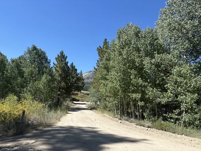
Obsidian campground offers opportunity to get away from crowds amidst shade of aspens and pines. Campground is close to Molybdenite Creek and Little Walker River. The river is stocked with trout. Area trailheads offer several interesting hikes. The trail from Molybdenite Creek trailhead splits, with one branch heading south into the Hoover Wilderness, and one looping north along Wheeler Creek to connect with the trail along the Little Walker River. This can be hiked as a loop from Burt Canyon trailhead (just west of campground). The Emma Lake trailhead leads to a short but steep hike to Emma Lake on the shores of Mount Emma.
Recreation
The Obsidian campground is popular with hikers, fishermen, and campers looking for a quiet rustic campground.
Facilities
This campground is best suited for small vehicles and tent camping. Campsites have picnic tables and campfire rings. The campground has vault toilets for public use. There is no garbage service so please pack in/pack out any trash. There is no potable water available.
Natural Features
The Obsidian campground is at an elevation of 7800 feet.
The facts
- Season: Late May – Mid-October — USDA Forest Service, Aug 24, 2026
- 11 bookable sites
- Up to 6 people per site
- Loops: Obsidian
Site types
- 11 Standard Nonelectric
Amenities
- Campfires allowed
- Pets allowed
- Water hookups — not available
Not recorded upstream: electric hookups, sewer hookups, fire pits, picnic tables, grills, shade.
11 campsites at Obsidian
Check-in 02:00 PM · Check-out 12:00 PM
| Site | Loop | Type | Entry | Surface | Max rig | People | |
|---|---|---|---|---|---|---|---|
| 1 | Obsidian | Standard Nonelectric | — | — | — | 6 | 🐾 |
| 10 | Obsidian | Standard Nonelectric | — | — | — | 6 | 🐾 |
| 11 | Obsidian | Standard Nonelectric | — | — | — | 6 | 🐾 |
| 2 | Obsidian | Standard Nonelectric | — | — | — | 6 | 🐾 |
| 3 | Obsidian | Standard Nonelectric | — | — | — | 6 | 🐾 |
| 4 | Obsidian | Standard Nonelectric | — | — | — | 6 | 🐾 |
| 5 | Obsidian | Standard Nonelectric | — | — | — | 6 | 🐾 |
| 6 | Obsidian | Standard Nonelectric | — | — | — | 6 | 🐾 |
| 7 | Obsidian | Standard Nonelectric | — | — | — | 6 | 🐾 |
| 8 | Obsidian | Standard Nonelectric | — | — | — | 6 | 🐾 |
| 9 | Obsidian | Standard Nonelectric | — | — | — | 6 | 🐾 |
Getting there
38.29990, -119.44920 · 38°17'59.6"N 119°26'57.1"W
Typical weather
| Jan | Feb | Mar | Apr | May | Jun | Jul | Aug | Sep | Oct | Nov | Dec | |
|---|---|---|---|---|---|---|---|---|---|---|---|---|
| High °F | — | — | — | — | — | — | — | — | — | — | — | — |
| Low °F | — | — | — | — | — | — | — | — | — | — | — | — |
| Precip in | 5.7 | 5.3 | 4.4 | 2.2 | 1.5 | 0.6 | 0.8 | 0.6 | 0.7 | 2.3 | 3.5 | 5.3 |
1991–2020 averages from the nearest NOAA station, 5.5 mi away — not measured at the facility itself, and elevation can make a real difference over that distance.
Map
More photos

Member photos
Common questions about Obsidian
- Can you reserve a site at Obsidian?
- Yes, Obsidian is reservable through Recreation.gov.
- How many campsites does Obsidian have?
- 11 sites.
- Are pets allowed at Obsidian?
- Yes, pets are allowed at Obsidian.
- Does Obsidian have hookups?
- No hookups are recorded here.
- Are campfires allowed at Obsidian?
- Campfires are allowed at Obsidian. Check for a current fire restriction before you go.
Also listed by
Obsidian also appears in other federal recreation data. Facts below are matched by name and location, not confirmed by Obsidian's operator.
USDA Forest Service — data as of Aug 24, 2026
- Per Day: $18 Single/$6 Extra Vehicles
Restrictions:
- California camp fire permit required ( https://www.fs.usda.gov/detail/htnf/passes-permits/?cid=fseprd673196 ).
- Dog must be on a leash at campground.
Camping near Obsidian
- Sonora Bridge 5 mi · Campground · we watch it
- Leavitt Meadows 6.3 mi · Campground · we watch it
- Chris Flat 6.5 mi · Campground · we watch it
- Buckeye 7.9 mi · Campground · we watch it
- Bootleg 8.1 mi · Campground · we watch it
- Honeymoon Flat 9.8 mi · Campground · we watch it
- Robinson Creek North 10.6 mi · Campground · we watch it
- Robinson Creek South 10.6 mi · Campground · we watch it
- Paha 10.7 mi · Campground · we watch it
- Lower Twin Lakes AT Bridgeport 10.9 mi · Campground · we watch it
- Paha Campground 10.5 mi · Campground
- Crags Campground 11 mi · Campground
Contact
- Phone 760-932-7070
- Book Recreation.gov
Recreation.gov last updated this record on 2026-02-25.
Facility information and photographs from Recreation.gov (RIDB). SpotOpened is not affiliated with Recreation.gov or any federal agency.
Comments