Moose Creek Flat Campground
Campground · 14 bookable sites ·
Managed by the USDA Forest Service
Gallatin National Forest (NF) · Open Access
- 14
- Bookable sites
- up to 50
- People per site
- 5,702 ft
- Elevation
Overview
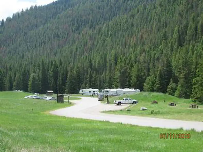
Moose Creek Flat Campground is located in scenic Gallatin Canyon on the Bozeman Ranger District of the Gallatin National Forest, in Montana. It is 32 miles south of Bozeman.The surrounding area offers many outdoor recreational opportunities, including fishing, rafting, hiking and viewing local wildlife.
Recreation
The surrounding area provides great opportunities for hiking, fishing, scenic driving and wildlife viewing. Anglers cast for rainbow, brown, brook and cutthroat trout, whitefish and Arctic grayling on the Gallatin River. An accessible fishing dock is located at the river's edge. Rafting and kayaking are popular activities as well.Many trails can be found in Gallatin Canyon. The Swan Creek Trail begins at nearby Swan Creek Campground. Golden Trout Lakes Trail begins about 15 minutes away up Portal Creek Road, three miles south of the campground.
Facilities
This fully accessible campground offers several single-family campsites, each equipped with a picnic table and campfire ring. A GROUP PICNIC AREA (SITE 14) for DAY USE ONLY equipped with 3 standard size picnic tables is also available and can accommodate up to 50 people.
Vault toilets, drinking water and trash collection are provided. Roads within the campground are paved, but the parking spurs are gravel.
Natural Features
The campground sits next to the Gallatin River near Moose Creek, just off Highway 191, at an elevation of 5,700 feet. A forest of pine and fir trees covers the surrounding mountainsides, but the campground itself lies in an open meadow.A variety of wildlife makes its home in this scenic canyon. Visitors can often catch a glimpse of bald eagles, bighorn sheep, moose, elk, mountain goats, deer and coyotes. Black and grizzly bears also live in the canyon.
Contact Info
For facility specific information, please call (661) 702-1420.The facts
- 14 bookable sites
- 1 site for day use only
- Up to 50 people per site
- Loops: AREA MOOSE CREEK FLAT CAMPGROUND
Site types
- 13 Standard Nonelectric
- 1 Group Picnic Area
Amenities
- Campfires allowed
- Fire pits
- Picnic tables
- Pets allowed
- Water hookups — not available
- Sewer hookups — not available
Not recorded upstream: electric hookups, grills, shade.
14 campsites at Moose Creek Flat Campground
Check-in 2:00 PM · Check-out 12:00 PM
| Site | Loop | Type | Entry | Surface | Max rig | People | |
|---|---|---|---|---|---|---|---|
| 001 | AREA MOOSE CREEK FLAT CAMPGROUND | Standard Nonelectric | Back In | Gravel | — | 8 | 🐾 |
| 002 | AREA MOOSE CREEK FLAT CAMPGROUND | Standard Nonelectric | Back In | Gravel | — | 8 | 🐾 |
| 003 | AREA MOOSE CREEK FLAT CAMPGROUND | Standard Nonelectric | Back In | Gravel | — | 8 | 🐾 |
| 004 | AREA MOOSE CREEK FLAT CAMPGROUND | Standard Nonelectric | Back In | Gravel | — | 8 | 🐾 |
| 005 | AREA MOOSE CREEK FLAT CAMPGROUND | Standard Nonelectric | Back In | Gravel | — | 8 | 🐾 |
| 006 | AREA MOOSE CREEK FLAT CAMPGROUND | Standard Nonelectric | Back In | Gravel | — | 8 | 🐾 |
| 007 | AREA MOOSE CREEK FLAT CAMPGROUND | Standard Nonelectric | Back In | Gravel | — | 8 | 🐾 |
| 008 | AREA MOOSE CREEK FLAT CAMPGROUND | Standard Nonelectric | Back In | Gravel | — | 8 | 🐾 |
| 009 | AREA MOOSE CREEK FLAT CAMPGROUND | Standard Nonelectric | Back In | Gravel | — | 8 | 🐾 |
| 010 | AREA MOOSE CREEK FLAT CAMPGROUND | Standard Nonelectric | Pull Through | Gravel | — | 8 | 🐾 |
| 011 | AREA MOOSE CREEK FLAT CAMPGROUND | Standard Nonelectric | Pull Through | Gravel | — | 8 | 🐾 |
| 012 | AREA MOOSE CREEK FLAT CAMPGROUND | Standard Nonelectric | Pull Through | Gravel | — | 8 | 🐾 |
| 013 | AREA MOOSE CREEK FLAT CAMPGROUND | Standard Nonelectric | Pull Through | Gravel | — | 8 | 🐾 |
| 014 Day Use | AREA MOOSE CREEK FLAT CAMPGROUND | Group Picnic Area | Back In | Gravel | — | 50 | 🐾 |
Getting there
45.35667, -111.17139 · 45°21'24.0"N 111°10'17.0"W
Typical weather
| Jan | Feb | Mar | Apr | May | Jun | Jul | Aug | Sep | Oct | Nov | Dec | |
|---|---|---|---|---|---|---|---|---|---|---|---|---|
| High °F | — | — | — | — | — | — | — | — | — | — | — | — |
| Low °F | — | — | — | — | — | — | — | — | — | — | — | — |
| Precip in | 1.4 | 1.1 | 1.8 | 2.6 | 3.2 | 3.5 | 1.5 | 1.6 | 1.7 | 2.2 | 1.3 | 1.1 |
1991–2020 averages from the nearest NOAA station, 6.9 mi away — not measured at the facility itself, and elevation can make a real difference over that distance.
Map
Member photos
Common questions about Moose Creek Flat Campground
- Can you reserve a site at Moose Creek Flat Campground?
- Yes, Moose Creek Flat Campground is reservable through Recreation.gov.
- How many campsites does Moose Creek Flat Campground have?
- 14 sites.
- Are pets allowed at Moose Creek Flat Campground?
- Yes, pets are allowed at Moose Creek Flat Campground.
- Does Moose Creek Flat Campground have hookups?
- No hookups are recorded here.
- Are campfires allowed at Moose Creek Flat Campground?
- Campfires are allowed at Moose Creek Flat Campground. Check for a current fire restriction before you go.
Camping near Moose Creek Flat Campground
- Moose Creek Group Site 0.4 mi · Campground · we watch it
- Swan Creek Campground 1.1 mi · Campground · we watch it
- Greek Creek Campground 1.7 mi · Campground · we watch it
- Garnet Mountain Fire Lookout 5.1 mi · Campground · we watch it
- Spire Rock Campground 6.1 mi · Campground · we watch it
- Windy Pass Cabin 7.2 mi · Campground · we watch it
- Little Bear Cabin 9.7 mi · Campground · we watch it
- Fox Creek Cabin (MT) 10.5 mi · Campground · we watch it
- Spanish Creek Cabin 11.8 mi · Campground · we watch it
- Big Creek Cabin 12.5 mi · Campground · we watch it
- Moose Creek Flat Campground 1.7 mi · Campground
- Spire Rock Campground 5.8 mi · Campground
Contact
- Phone (406)646-1012
- Email dhagey@goexplorus.com
- Book Recreation.gov
Recreation.gov last updated this record on 2026-02-25.
Facility information and photographs from Recreation.gov (RIDB). SpotOpened is not affiliated with Recreation.gov or any federal agency.
Comments