Langohr Campground
Campground · 19 bookable sites ·
Managed by the USDA Forest Service
Gallatin National Forest (NF) · Open Access
- 19
- Bookable sites
- 45 ft
- Max rig length
- up to 50
- People per site
- 3
- Accessible sites
- 6,136 ft
- Elevation
Overview
Langohr Campground is located in scenic Hyalite Canyon on the Bozeman Ranger District of the Gallatin National Forest. It is located just 12 miles south of Bozeman, Mont.The surrounding area offers many outdoor recreational opportunities, including fishing, hiking and climbing.
Recreation
Hyalite Creek provides great fishing for Yellowstone cutthroat, Arctic grayling and brook trout. Many hiking trails can be found in Hyalite Canyon.Facilities
The campground offers several single-family campsites. A GROUP PICNIC AREA (SITE 20) for DAY USE ONLY is also available and can accommodate up to 50 people. Tables and campfire rings are provided, as are vault toilets, drinking water and trash collection.
Natural Features
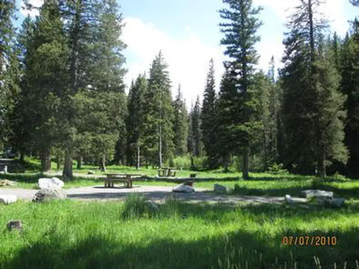
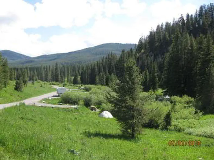
The campground sits next to Hyalite Creek, at an elevation of 6,200 feet. Most campsites are situated in open meadows along the creek. Some are located among scattered pine and fir trees.Nearby Attractions
Hyalite Reservoir is just 3.5 miles from the campground. The scenic 206-acre lake offers many recreational activities, including boating, canoeing, fishing, hiking, climbing and picnicking.The popular Hyalite Peak Trail begins near the reservoir. The 7.5-mile one-way trail gains 3,450 feet in elevation as is climbs past numerous waterfalls to beautiful Hyalite Lake and Peak.
Contact Info
For facility specific information, please call (661) 702-1420.The facts
- Season: 5/16 - 10/15 Limited Service 9/24 - 12/1 — USDA Forest Service, Aug 24, 2026
- 19 bookable sites
- 20 sites in total, including non-bookable
- 1 site for day use only
- 3 accessible sites
- Vehicles up to 45 ft
- Up to 50 people per site
- Loops: LANG
Site types
- 17 Standard Nonelectric
- 1 Group Picnic Area
- 1 Management
- 1 Tent Only Nonelectric
Amenities
- Campfires allowed
- Fire pits
- Picnic tables
- Shade
- Pets allowed
- Water hookups — not available
- Sewer hookups — not available
Not recorded upstream: electric hookups, grills.
20 campsites at Langohr Campground
| Site | Loop | Type | Entry | Surface | Grade | Max rig | People | |
|---|---|---|---|---|---|---|---|---|
| 001 | LANG | Standard Nonelectric | Pull Through | Gravel | — | 45 ft | 8 | 🐾 |
| 002 | LANG | Standard Nonelectric | Pull Through | Gravel | Slight | 38 ft | 8 | 🐾 |
| 003 | LANG | Standard Nonelectric | Pull Through | Gravel | Slight | 45 ft | 8 | ♿ 🐾 |
| 004 | LANG | Tent Only Nonelectric | Back In | Gravel | — | 25 ft | 8 | ♿ 🐾 |
| 005 | LANG | Standard Nonelectric | Back In | Gravel | — | 21 ft | 8 | 🐾 |
| 006 | LANG | Standard Nonelectric | Back In | Gravel | — | 38 ft | 8 | 🐾 |
| 007 | LANG | Standard Nonelectric | Pull Through | Gravel | — | 45 ft | 8 | 🐾 |
| 008 | LANG | Standard Nonelectric | Back In | Gravel | — | 40 ft | 8 | 🐾 |
| 009 | LANG | Standard Nonelectric | Back In | Gravel | — | 45 ft | 8 | 🐾 |
| 010 | LANG | Standard Nonelectric | Back In | Gravel | — | 32 ft | 8 | 🐾 |
| 011 Host | LANG | Management | Back In | Paved | — | — | 8 | 🐾 |
| 012 | LANG | Standard Nonelectric | Back In | Gravel | — | 24 ft | 8 | 🐾 |
| 013 | LANG | Standard Nonelectric | Parallel | Gravel | — | 45 ft | 8 | 🐾 |
| 014 | LANG | Standard Nonelectric | Back In | Gravel | — | 38 ft | 8 | 🐾 |
| 015 | LANG | Standard Nonelectric | Parallel | Paved | — | 45 ft | 8 | 🐾 |
| 016 | LANG | Standard Nonelectric | Back In | Gravel | — | 31 ft | 8 | 🐾 |
| 017 | LANG | Standard Nonelectric | Back In | Gravel | — | 40 ft | 16 | 🐾 |
| 018 | LANG | Standard Nonelectric | Back In | Gravel | — | 40 ft | 16 | 🐾 |
| 019 | LANG | Standard Nonelectric | Back In | Gravel | — | 20 ft | 8 | 🐾 |
| 020 Day Use | LANG | Group Picnic Area | — | Gravel | — | — | 50 | ♿ 🐾 |
Getting there
45.53361, -111.01500 · 45°32'1.0"N 111°0'54.0"W
Typical weather
| Jan | Feb | Mar | Apr | May | Jun | Jul | Aug | Sep | Oct | Nov | Dec | |
|---|---|---|---|---|---|---|---|---|---|---|---|---|
| High °F | — | — | — | — | — | — | — | — | — | — | — | — |
| Low °F | — | — | — | — | — | — | — | — | — | — | — | — |
| Precip in | 1.8 | 2.0 | 2.6 | 4.0 | 4.2 | 3.7 | 1.4 | 1.4 | 1.7 | 2.6 | 2.3 | 2.0 |
1991–2020 averages from the nearest NOAA station, 3.2 mi away — not measured at the facility itself, and elevation can make a real difference over that distance.
Map
More photos
Member photos
Common questions about Langohr Campground
- Can you reserve a site at Langohr Campground?
- Yes, Langohr Campground is reservable through Recreation.gov.
- How many campsites does Langohr Campground have?
- 20 sites in total, of which 19 can be booked.
- What is the maximum RV length at Langohr Campground?
- 45 ft. That is the longest vehicle the sites here are recorded as taking; individual sites may be shorter.
- Are pets allowed at Langohr Campground?
- Yes, pets are allowed at Langohr Campground.
- Does Langohr Campground have hookups?
- No hookups are recorded here.
- Are campfires allowed at Langohr Campground?
- Campfires are allowed at Langohr Campground. Check for a current fire restriction before you go.
Also listed by
Langohr Campground also appears in other federal recreation data. Facts below are matched by name and location, not confirmed by Langohr Campground's operator.
USDA Forest Service — data as of Aug 24, 2026
- $9.00 each additional vehicle. Interagency Passes not applicable toward additional vehicle fees.
Accessibility:
- Accessible Facilities: Fishing, Toilet, Trail, 2 sites
Camping near Langohr Campground
- Lower Hyalite Group 1.9 mi · Campground · we watch it
- Fox Creek Cabin (MT) 4 mi · Campground · we watch it
- Hood Creek Campground 4.1 mi · Campground · we watch it
- Hyalite Pavilion 4.1 mi · Campground · we watch it
- Mystic Lake Cabin 4.7 mi · Campground · we watch it
- Maxey Cabin 4.9 mi · Campground · we watch it
- Chisholm Campground 5 mi · Campground · we watch it
- Window Rock Cabin 5.6 mi · Campground · we watch it
- Little Bear Cabin 7 mi · Campground · we watch it
- Trail Creek Cabin 9 mi · Campground · we watch it
- Hyalite Day Use area and Hyalite Pavilion 3.7 mi · Facility
- Blackmore Picnic Area 3.7 mi · Facility
Contact
- Phone (406)646-1012
- Email dhagey@goexplorus.com
- Book Recreation.gov
Recreation.gov last updated this record on 2026-03-11.
Facility information and photographs from Recreation.gov (RIDB). SpotOpened is not affiliated with Recreation.gov or any federal agency.
Comments