Gauley Tailwaters
Facility ·
Managed by the National Park Service
Summersville Recreation Area (Recreation Area) · Open Access
- 1,456 ft
- Elevation
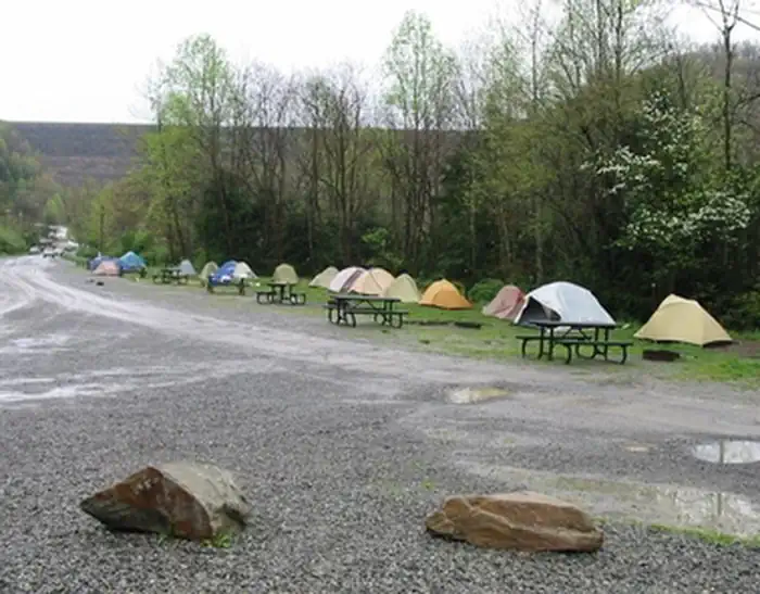
The National Park Service offers primitive camping at Gauley Tailwaters, located just below Summersville Dam. From Route 19 at Mt. Nebo, take Route 129 west across the dam, then turn left at the river access sign. Bear right through the parking lot to the campsites. There are 18 drive-in sites for tents and RVs.
Camp only at designated sites. RV, camper, or car camping in non-designated sites, walk-in sites, or any parking area is strictly prohibited.
Getting there
The National Park Service offers primitive camping at Gauley Tailwaters, located just below Summersville Dam. From Route 19 at Mt. Nebo, take Route 129 west across the dam, then turn left at the river access sign. Bear right through the parking lot to the campsites. There are 18 drive-in sites for tents and RVs.
38.21439, -80.88885 · 38°12'51.8"N 80°53'19.9"W
Typical weather
Typically 81°F in Jul, down to 41°F in Jan.
| Jan | Feb | Mar | Apr | May | Jun | Jul | Aug | Sep | Oct | Nov | Dec | |
|---|---|---|---|---|---|---|---|---|---|---|---|---|
| High °F | 41 | 44 | 52 | 65 | 72 | 78 | 81 | 80 | 76 | 65 | 54 | 45 |
| Low °F | 21 | 23 | 29 | 38 | 48 | 57 | 61 | 59 | 53 | 41 | 32 | 26 |
| Precip in | 3.5 | 3.1 | 4.3 | 4.2 | 5.3 | 5.2 | 5.8 | 4.2 | 3.8 | 3.3 | 3.3 | 3.9 |
1991–2020 averages from the nearest NOAA station, 0.5 mi away — not measured at the facility itself, and elevation can make a real difference over that distance.
Map
Member photos
Common questions about Gauley Tailwaters
- Can you reserve a site at Gauley Tailwaters?
- No. Gauley Tailwaters is not reservable through Recreation.gov, so sites are first-come, first-served or booked elsewhere.
Camping near Gauley Tailwaters
- Summersville Lake Shelters 0.5 mi · Campground · we watch it
- Battle Run 1.2 mi · Campground · we watch it
- Burnwood Group Campsite 14.1 mi · Facility
- Canyon Rim Visitor Center 14.2 mi · Facility
- Canyon Rim Visitor Center 14.2 mi · Facility
- Brooklyn Campground 17.6 mi · Campground
- Big Rock Campground 20.6 mi · Campground
- Cranberry River Sites 21 mi · Campground
- Stone Cliff 21.6 mi · Facility
- Thayer Campground 23 mi · Facility
- Bishop Knob Campground 23.3 mi · Campground
- Summit Lake Campground 24.2 mi · Campground
Contact
- Phone (304) 465-0508
- Email neri_interpretation@nps.gov
- Info Recreation.gov
Recreation.gov last updated this record on 2026-02-25.
Facility information and photographs from Recreation.gov (RIDB). SpotOpened is not affiliated with Recreation.gov or any federal agency.
Comments