Badger Springs Recreation Area and Trailhead
Facility ·
Managed by the Bureau of Land Management
Agua Fria National Monument (BLM_MON) · Open Access
- 3,132 ft
- Elevation
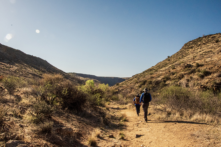
Badger Springs Trailhead leads to a short, non-motorized trail through Badger Springs Wash into the Agua Fria River canyon. The trail features desert terrain, seasonal water flow, and a mix of sandy washes and rocky areas.
The trail leads to a well-preserved panel of petroglyphs where the Badger Springs Wash meets the Agua Fria River. Along the way, visitors can enjoy birding, wildlife viewing, and peaceful riverside terrain. Wildlife such as mule deer, javelina, and coyotes may be seen along the trail.
Hours and Seasons
Open year-round, 24 hours a day. The Agua Fria River typically flows through early summer; the wash may be wet or muddy during that season
Features and Services
- Access and Parking: The trailhead is adjacent to a gravel parking lot located off maintained dirt road.
- Cell Service: Limited; reception is spotty in this remote area.
- Toilets: Accessible vault toilet near the trailhead
- Drinking Water: None.
- Pets: Permitted on leash; please remove pet waste.
- Camping: Primitive, dispersed camping is permitted on nearby BLM lands; check local regulations for fire and camping guidelines.
- Nearby Amenities: Black Canyon City and Cordes Lakes offer food, fuel, lodging, and basic medical services.
Respect and Protect
Historic and archaeological sites are protected by law. Please leave cultural artifacts and petroglyphs untouched. By practicing responsible outdoor ethics, you help ensure future visitors can enjoy this remarkable site.
Getting there
From I‑17 at the Badger Springs exit (Exit 256), drive east on Badger Springs Road (dirt) for about 0.8 miles to a gravel parking lot.
34.23141, -112.10013 · 34°13'53.1"N 112°6'0.5"W
Typical weather
Typically 96°F in Jul, down to 58°F in Dec.
| Jan | Feb | Mar | Apr | May | Jun | Jul | Aug | Sep | Oct | Nov | Dec | |
|---|---|---|---|---|---|---|---|---|---|---|---|---|
| High °F | 59 | 61 | 67 | 74 | 83 | 93 | 96 | 94 | 89 | 79 | 67 | 58 |
| Low °F | 34 | 35 | 38 | 42 | 50 | 58 | 66 | 66 | 60 | 49 | 39 | 33 |
| Precip in | 1.7 | 1.9 | 1.4 | 0.4 | 0.4 | 0.1 | 2.0 | 2.1 | 1.6 | 1.1 | 1.0 | 1.5 |
1991–2020 averages from the nearest NOAA station, 6.3 mi away — not measured at the facility itself, and elevation can make a real difference over that distance.
Map
Fees and stay limits
The Badger Springs Trail is free (no fee required) for general visits by the public. However, commercial, competitive, and large organized group events require a special recreation permit. Contact the Hassayampa Field Office for more information about special recreation permits.
From Recreation.gov, which is not always current. The operator's own page is the authority on what you will be charged.
Member photos
Common questions about Badger Springs Recreation Area and Trailhead
- Can you reserve a site at Badger Springs Recreation Area and Trailhead?
- No. Badger Springs Recreation Area and Trailhead is not reservable through Recreation.gov, so sites are first-come, first-served or booked elsewhere.
Camping near Badger Springs Recreation Area and Trailhead
- Sycamore Cabin 11.1 mi · Campground · we watch it
- Turney Gulch Group 11.3 mi · Campground · we watch it
- Horsethief Cabin 12 mi · Campground · we watch it
- Pueblo La Plata Cultural Site 4.3 mi · Facility
- Teskey Home Site 5.8 mi · Facility
- Riverbend Recreation Area and 1891 Schoolhouse 6.1 mi · Facility
- Big Bug Trailhead 10.1 mi · Facility
- Castle Creek Wilderness 11.4 mi · Facility
- Hazlett Hollow Campground 11.4 mi · Campground
- Dugas - Tule Mesa 11.8 mi · Facility
- Black Canyon City Trailhead 12.7 mi · Facility
- Crown King Area (Horsethief Basin) 13.6 mi · Facility
Contact
- Phone 602-867-5400
- Email blm_az_pdoweb@blm.gov
- Info Recreation.gov
Recreation.gov last updated this record on 2026-04-23.
Facility information and photographs from Recreation.gov (RIDB). SpotOpened is not affiliated with Recreation.gov or any federal agency.
Comments