Aitch Picnic Shelter
Campground · Pennsylvania · 1 bookable site ·
Managed by the US Army Corps of Engineers
Raystown Recreation Area (Recreation Area) · Open Access
- 1
- Bookable site
- up to 80
- People per site
- 1
- Accessible site
- 801 ft
- Elevation
Overview
Aitch Recreation Area is located approximately near the geographic middle of Raystown Lake along the western side. The recreation area is easily accessible from US Route 26 and offers a great location for picnicking and fishing on an accessible pier.Recreation
Lakeside fishing piers and excellent aquatic habitat makes Aitch a popular area for shoreline anglers. A boat ramp within the facility provides access to the 8,300-acre Raystown Lake, which is popular for boating, camping and fishing.Facilities
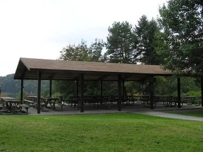
Aitch offers one group shelter with approximately 10 tables and 20-amp electrical outlets. It is fully accessible and comfortably accommodates up to 80 people with a view of the lake.Natural Features
Aitch is situated in a cove of Raystown Lake. Nearby access to the lake makes this shelter a great place to picnic, fish and boat.Nearby Attractions
The area offers Aitch Boat Launch, James Creek Boat Launch, Tatman Run Recreation Area, Lake Raystown Resort, Seven Points Recreation Area and the Seven Points Marina.The facts
- 1 bookable site
- 1 site for day use only
- 1 accessible site
- Up to 80 people per site
- Loops: Aitch Picnic Shelter
Site types
- 1 Group Shelter Electric
Amenities
- Electric hookups
- Water hookups
- Picnic tables
- Shade
- Pets allowed
Not recorded upstream: sewer hookups, campfires allowed, fire pits, grills.
1 campsite at Aitch Picnic Shelter
Check-in 6:00 AM · Check-out 10:00 PM
| Site | Loop | Type | Entry | Surface | Water | Max rig | People | |
|---|---|---|---|---|---|---|---|---|
| 01 | Aitch Picnic Shelter | Group Shelter Electric | — | — | Lakefront | — | 80 | ♿ 🐾 |
Getting there
Aitch is located near the town of Marklesburg, PA. From Huntingdon continue 10.5 miles southbound along Rt. 26 to Marklesburg. At Markelsburg turn left onto Aitch Road (marked by sign). Aitch Road leads directly to the Shelter location (0.8 miles).
40.37611, -78.16261 · 40°22'34.0"N 78°9'45.4"W
Typical weather
Typically 85°F in Jul, down to 37°F in Jan.
| Jan | Feb | Mar | Apr | May | Jun | Jul | Aug | Sep | Oct | Nov | Dec | |
|---|---|---|---|---|---|---|---|---|---|---|---|---|
| High °F | 37 | 40 | 49 | 62 | 72 | 80 | 85 | 84 | 76 | 64 | 52 | 42 |
| Low °F | 21 | 22 | 29 | 40 | 50 | 58 | 63 | 62 | 55 | 44 | 34 | 27 |
| Precip in | 2.8 | 2.3 | 3.1 | 3.7 | 4.4 | 3.8 | 3.8 | 3.5 | 3.9 | 3.4 | 2.9 | 3.1 |
1991–2020 averages from the nearest NOAA station, 4.6 mi away — not measured at the facility itself, and elevation can make a real difference over that distance.
Map
Member photos
Common questions about Aitch Picnic Shelter
- Can you reserve a site at Aitch Picnic Shelter?
- Yes, Aitch Picnic Shelter is reservable through Recreation.gov.
- How many campsites does Aitch Picnic Shelter have?
- 1 site.
- Are pets allowed at Aitch Picnic Shelter?
- Yes, pets are allowed at Aitch Picnic Shelter.
- Does Aitch Picnic Shelter have hookups?
- Electric, Water.
Camping near Aitch Picnic Shelter
- Nancy's Boat to Shore Campground (Pa) 2.4 mi · Campground · we watch it
- Seven Points (Pa) 4.5 mi · Campground · we watch it
- Tatman Run Picnic Shelter 4.5 mi · Campground · we watch it
- Susquehannock 6 mi · Campground · we watch it
- Corbin's Island Picnic Shelter 9.8 mi · Campground · we watch it
- Weaver Falls Shelter 9.9 mi · Campground · we watch it
- Seven Points Picnic Shelters 12.2 mi · Campground · we watch it
- Summit Level Visitor Center 21.1 mi · Facility
- Omni Bedford Springs Resort and Spa 32 mi · Facility
- Johnstown Flood National Memorial Visitor Center 32.1 mi · Facility
- Flight 93 Visitor Center 45 mi · Visitor Center
- Little Pool Hiker-Biker Campsite 47.8 mi · Campground
Contact
- Phone 814-658-3405
- Email kalee.m.anderson@usace.army.mil
- Book Recreation.gov
Recreation.gov last updated this record on 2026-02-25.
Facility information and photographs from Recreation.gov (RIDB). SpotOpened is not affiliated with Recreation.gov or any federal agency.
Comments