Boundary Waters Canoe Area Wilderness (Reservations)
Permit · Minnesota ·
Managed by the USDA Forest Service
Boundary Waters Canoe Area Wilderness · Restricted Access
- 1,596 ft
- Elevation
Overview:
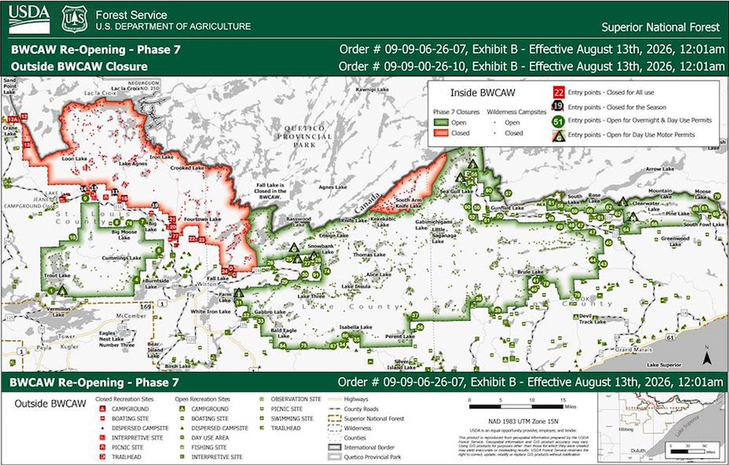
The Boundary Waters Canoe Area Wilderness (BWCAW) is located in the northern third of the Superior National Forest in northeastern Minnesota. Approximately 1.1 million acres in size, it extends nearly 150 miles along the international boundary adjacent to Canada's Quetico Provincial Park and is bordered on the west by Voyageurs National Park.The BWCAW offers more than 1,200 miles of canoe routes, 11 hiking trails and approximately 2,000 designated campsites.
The area was set aside in 1926 to preserve its primitive character and was made a part of the National Wilderness Preservation System in 1964. Visitors can canoe, portage and camp in the spirit of the french voyageurs of 200 years ago.
Any group taking an overnight paddle, motor or hiking trip, or a motorized day use trip into the BWCAW from May through September is required to obtain a quota permit.
Reservations are recommended since there are a limited number of quota permits available for each entry point. Self-issued permits are required year-round for all non-motorized day use visitors and for all overnight visitors entering the BWCAW between October and April. Self-issued permits are free and available at the entry point or Forest Service ranger stations.
For the most current, comprehensive information on planning a trip to the BWCAW, please review the BWCAW Trip Planning Guide here.
Getting there
None
48.03389, -90.99278 · 48°2'2.0"N 90°59'34.0"W
Typical weather
Typically 76°F in Jul, down to 15°F in Jan.
| Jan | Feb | Mar | Apr | May | Jun | Jul | Aug | Sep | Oct | Nov | Dec | |
|---|---|---|---|---|---|---|---|---|---|---|---|---|
| High °F | 15 | 20 | 33 | 47 | 62 | 71 | 76 | 74 | 64 | 49 | 34 | 21 |
| Low °F | -6 | -5 | 8 | 24 | 38 | 49 | 54 | 52 | 45 | 33 | 21 | 4 |
| Precip in | 1.0 | 0.8 | 1.0 | 1.9 | 2.9 | 3.6 | 3.7 | 2.8 | 3.5 | 2.7 | 1.6 | 1.1 |
1991–2020 averages from the nearest NOAA station, 10.1 mi away — not measured at the facility itself, and elevation can make a real difference over that distance.
Map
Ways in
Showing 40 of 89.
- Angleworm Lake (op) — Entry Point · Kawishiwi District
- Angleworm Lake Trail (oh) — Entry Point · Kawishiwi District
- Baker Lake (op) — Entry Point · Tofte District
- Big Moose Lake Trail (oh) — Entry Point · LaCroix District
- Blandin Trail (oh) — Entry Point · LaCroix District
- Bog Lake (op) — Entry Point · Tofte District
- Border Route Trail (center) (oh) — Entry Point · Gunflint District
- Border Route Trail (east) (oh) — Entry Point · Gunflint District
- Border Route Trail (west) (oh) — Entry Point · Gunflint District
- Bower Trout Lake (op) — Entry Point · Gunflint District
- Brant Lake (op) — Entry Point · Gunflint District
- Brule Lake (op) — Entry Point · Tofte District
- Brule Lake ONLY (op) — Entry Point · Tofte District
- Brule Lake Trail (oh) — Entry Point · Gunflint District
- Clearwater Lake (dm) — Entry Point · Gunflint District
- Clearwater Lake (op,om) — Entry Point · Gunflint District
- Crab Lake (op) — Entry Point · LaCroix District
- Crocodile River (op) — Entry Point · Gunflint District
- Cross Bay Lake (op) — Entry Point · Gunflint District
- Daniels Lake (op) — Entry Point · Gunflint District
- Duncan Lake (op) — Entry Point · Gunflint District
- Eagle Mountain Trail (oh) — Entry Point · Gunflint District
- East Bearskin (dm) — Entry Point · Gunflint District
- East Bearskin (op,om) — Entry Point · Gunflint District
- Fall Lake (op,om) — Entry Point · Kawishiwi District
- Fall Lake ONLY (dm) — Entry Point · Kawishiwi District
- Fall Lake and Beyond (dm,dc) — Entry Point · Kawishiwi District
- From Big Lake (op) — Entry Point · Kawishiwi District
- From Canada — Entry Point
- From Farm Lake (op,om) — Entry Point · Kawishiwi District
- Herriman Lake Trail (oh) — Entry Point · LaCroix District
- Hog Creek (op) — Entry Point · Tofte District
- Homer Lake (op) — Entry Point · Tofte District
- Isabella Lake (op) — Entry Point · Tofte District
- Island River (op) — Entry Point · Tofte District
- John Lake (op) — Entry Point · Gunflint District
- Kawishiwi Lake (op) — Entry Point · Tofte District
- Kekekabic Trail (east) (oh) — Entry Point · Gunflint District
- Kekekabic Trail (west) /Snowbank (oh) — Entry Point · Kawishiwi District
- Lac LaCroix ONLY (op, om) — Entry Point-Restricted · LaCroix District
More photos
Member photos
Common questions about Boundary Waters Canoe Area Wilderness (Reservations)
- Can you reserve a site at Boundary Waters Canoe Area Wilderness (Reservations)?
- Yes, Boundary Waters Canoe Area Wilderness (Reservations) is reservable through Recreation.gov.
Camping near Boundary Waters Canoe Area Wilderness (Reservations)
- Trails End Campground 9.9 mi · Campground · we watch it
- Sawbill Lake Campground - Superior National Forest 12.8 mi · Campground · we watch it
- Crescent Lake (MN) 17 mi · Campground · we watch it
- Iron Lake 17.6 mi · Campground · we watch it
- Ham Lake 8.7 mi · Facility
- Loon Lake 12.8 mi · Facility
- Kawishiwi Lake Rustic Campground 14.4 mi · Campground
- Gunflint Lake 15.1 mi · Facility
- Baker Lake Rustic Campground 15.4 mi · Campground
- Homer Lake 17.2 mi · Facility
- Little Gunflint Lake 18.7 mi · Facility
- Rice Lake 19.4 mi · Facility
Contact
- Book Recreation.gov
Recreation.gov last updated this record on 2026-02-25.
Facility information and photographs from Recreation.gov (RIDB). SpotOpened is not affiliated with Recreation.gov or any federal agency.
Comments