Pine National Scenic River Watercraft Permits (Huron Manistee)
Permit · Michigan ·
Managed by the USDA Forest Service
Pine, Michigan Wild and Scenic River (Scenic) · Open Access
- 827 ft
- Elevation
Overview:
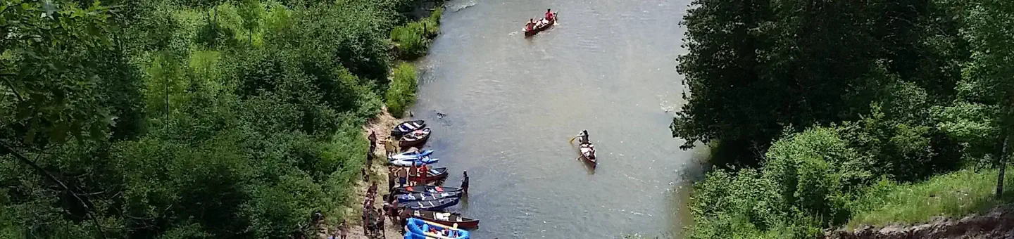
The lower 26 miles of the Pine River was designated as a National Scenic River in 1992. Scenery is one of the most outstanding attributes of the river. The designated portion of the river contains a unique riparian landform with a deeply incised river channel and high, exposed, fragile sand banks. Dense vegetation contributes to the picturesque setting of the river.Camping within the river corridor on National Forest lands is prohibited, except at Peterson Bridge Campground . Fees for using river access sites are charged under the Recreation Fee Enhancement Act. Check the bulletin board at each site for fees and additional information.
Getting there
From Manistee: Peterson Bridge North/Campground: Travel east on M-55 for 26 miles, turn right and travel south on M-37 for 1.5 miles, Day Use Area/Canoe Launch: the entrance is on the left before the bridge. Campground: The entrance is on the left south of the bridge. Other access sites include Elm Flats, Dobson Bridge, and Low Bridge.
44.20194, -85.79806 · 44°12'7.0"N 85°47'53.0"W
Typical weather
| Jan | Feb | Mar | Apr | May | Jun | Jul | Aug | Sep | Oct | Nov | Dec | |
|---|---|---|---|---|---|---|---|---|---|---|---|---|
| High °F | — | — | — | — | — | — | — | — | — | — | — | — |
| Low °F | — | — | — | — | — | — | — | — | — | — | — | — |
| Precip in | 2.4 | 1.8 | 2.3 | 3.4 | 3.5 | 3.5 | 3.2 | 3.1 | 3.3 | 4.2 | 3.1 | 2.5 |
1991–2020 averages from the nearest NOAA station, 8 mi away — not measured at the facility itself, and elevation can make a real difference over that distance.
Map
Ways in
Showing 1 of 1.
- Pine River — Boat Launch
More photos
Member photos
Common questions about Pine National Scenic River Watercraft Permits (Huron Manistee)
- Can you reserve a site at Pine National Scenic River Watercraft Permits (Huron Manistee)?
- Yes, Pine National Scenic River Watercraft Permits (Huron Manistee) is reservable through Recreation.gov.
Camping near Pine National Scenic River Watercraft Permits (Huron Manistee)
- Peterson Bridge 0.2 mi · Campground · we watch it
- Upper Manistee River Backcountry Campsites 6.5 mi · Campground · we watch it
- Sand Lake Campground 6.9 mi · Campground · we watch it
- Seaton Creek Campground 10.8 mi · Campground · we watch it
- Marzinski Horse Campground 18.1 mi · Campground · we watch it
- Low Bridge Canoe Landing 5.3 mi · Facility
- Elm Flats Canoe Landing 5.6 mi · Facility
- Old Grade Campground 10.1 mi · Campground
- Pine Lake Campground 10.5 mi · Campground
- Bear Track Campground 12.1 mi · Campground
- Udell Trailhead 13.9 mi · Facility
- Hemlock Campground and Boat Launch 14.8 mi · Campground
Contact
- Email r9_hmnf_website@fs.fed.us
- Book Recreation.gov
Recreation.gov last updated this record on 2026-02-25.
Facility information and photographs from Recreation.gov (RIDB). SpotOpened is not affiliated with Recreation.gov or any federal agency.
Comments