Ewing Point Campsite
Campground · Michigan · 1 bookable site ·
Managed by the USDA Forest Service
Hiawatha National Forest (NF) · Open Access
- 1
- Bookable site
- up to 8
- People per site
- 783 ft
- Elevation

Overview
The Munising and Rapid River/Manistique Ranger Districts of the Hiawatha National Forest offer a variety of camping experiences. Many are located on inland lakes in a rustic forest environment with no drinking water. The rustic environment offers a wonderfully serene and peaceful setting for your next camping experience.
Recreation
Visitors will be able to enjoy swimming, berry picking, and fishing at these dispersed campsites. Licenses are required for fishing in Michigan waters.
Bruno's Run Hiking Trail weaves throughout the Ewing Point area, offering 9 miles of adventure for hikers. The trail is accessible at various locations, two of which are near the Ewing Point parking area. One section of the trail leads to Grassy Lake, while the other heads along the southeastern portion of McKeever Lake.
McKeever Lake offers great fishing for musky, pike, bass and pan fish, and there is boat access in the parking area. Boats must be carried to the site by hand or through the water. Because the water is quite shallow, large boats are not recommended.
Facilities
There is NO drinking water at the site. Drinking water must be carried in. Water is available at Pete's Lake Campground.
There is a pit toilet available.
Lake Name: McKeever Lake
Number of Sites: 1
Maximum Number of People Per Site: 8
Toilets: 1 (Pit Toilet)
Boat Access: Back-In
Lake Size (acres): 132
Natural Features
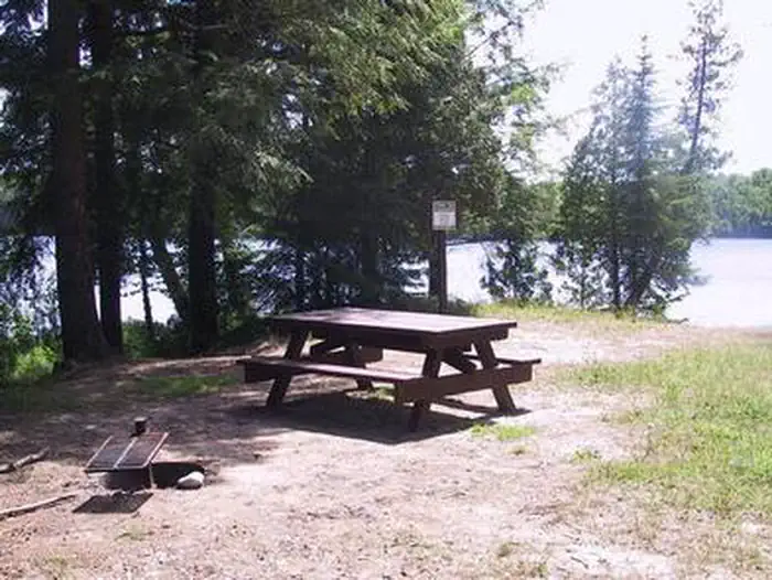
Ewing Point is a beautiful walk-in campsite located on the north side of the 132-acre McKeever Lake. The grassy site is 50 ft x 75 ft, surrounded by hemlock and cedar.
Contact Info
For local information, please call (906) 474-6442 or call (906) 387-2512 for general information.The facts
- Season: May 15 – Columbus Day — USDA Forest Service, Aug 24, 2026
- 1 bookable site
- Up to 8 people per site
- Loops: Ewing Point
Site types
- 1 Tent Only Nonelectric
Amenities
- Campfires allowed
- Picnic tables
- Grills
- Shade
- Pets allowed
Not recorded upstream: electric hookups, water hookups, sewer hookups, fire pits.
1 campsite at Ewing Point Campsite
Check-in 2:00 PM · Check-out 12:00 PM
| Site | Loop | Type | Entry | Surface | Access | Water | Max rig | People | |
|---|---|---|---|---|---|---|---|---|---|
| 001 | Ewing Point | Tent Only Nonelectric | — | — | Hike In | Lakefront | — | 8 | 🐾 |
Getting there
From Munising, MI: take State Route M-28 to Wetmore and turn south (right) on Forest Highway 13.
- Travel about 15 miles, then turn left on Forest Service Road 2173 at the Petes Lake Campground sign.
- Turn south (right) at the sign for McKeever Lake. The campsite is accessed through the boat launch area.
46.21788, -86.58874 · 46°13'4.4"N 86°35'19.5"W
Typical weather
| Jan | Feb | Mar | Apr | May | Jun | Jul | Aug | Sep | Oct | Nov | Dec | |
|---|---|---|---|---|---|---|---|---|---|---|---|---|
| High °F | — | — | — | — | — | — | — | — | — | — | — | — |
| Low °F | — | — | — | — | — | — | — | — | — | — | — | — |
| Precip in | 2.3 | 1.8 | 1.6 | 2.6 | 3.3 | 3.3 | 3.8 | 2.8 | 3.7 | 4.7 | 3.1 | 2.6 |
1991–2020 averages from the nearest NOAA station, 9.1 mi away — not measured at the facility itself, and elevation can make a real difference over that distance.
Map
More photos
Member photos
Common questions about Ewing Point Campsite
- Can you reserve a site at Ewing Point Campsite?
- Yes, Ewing Point Campsite is reservable through Recreation.gov.
- How many campsites does Ewing Point Campsite have?
- 1 site.
- Are pets allowed at Ewing Point Campsite?
- Yes, pets are allowed at Ewing Point Campsite.
- Are campfires allowed at Ewing Point Campsite?
- Campfires are allowed at Ewing Point Campsite. Check for a current fire restriction before you go.
Also listed by
Ewing Point Campsite also appears in other federal recreation data. Facts below are matched by name and location, not confirmed by Ewing Point Campsite's operator.
USDA Forest Service — data as of Aug 24, 2026
- Camping fee is $8 per night per site. Federal Recreation Passes (Golden/America the Beautiful) are accepted.
Camping near Ewing Point Campsite
- McKeever Cabin 0.5 mi · Campground · we watch it
- Pete’s Lake Campground 0.8 mi · Campground · we watch it
- Widewaters Campground 1.9 mi · Campground · we watch it
- Cookson Lake Campsites 2 mi · Campground · we watch it
- Council Lake Campsites 3.2 mi · Campground · we watch it
- Ironjaw Lake Campsite 3.7 mi · Campground · we watch it
- Lake Nineteen Campsite 3.8 mi · Campground · we watch it
- Pete's Lake Campground 1.4 mi · Campground
- McKeever Cabin 1.4 mi · Campground
- Council Lake Campsites 2.1 mi · Campground
- Big Island Lake Wilderness 2.2 mi · Facility
- Swan Lake Campsites 3.2 mi · Campground
Contact
- Phone 906-387-2512
- Book Recreation.gov
Recreation.gov last updated this record on 2026-03-11.
Facility information and photographs from Recreation.gov (RIDB). SpotOpened is not affiliated with Recreation.gov or any federal agency.
Comments