South Overlook (Ia)
Campground · Iowa · 2 bookable sites ·
Managed by the US Army Corps of Engineers
Lake Red Rock (Federal Lands and Waters) · Open Access
- 2
- Bookable sites
- up to 250
- People per site
- 1
- Accessible site
- 832 ft
- Elevation
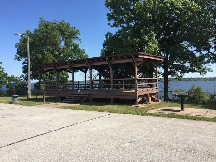
Overview
South Overlook is located on Lake Red Rock, Iowa's largest lake. It is just 10 miles from Pella, known for its Dutch heritage, and 15 miles from Knoxville, the Sprint car capital of the world. Visitors enjoy boating, fishing, hiking, biking and viewing wildlife.
For more information regarding the Army Corps of Engineers and the Lake Red Rock Project, click here: Lake Red Rock Website
Features
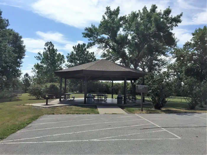
Octagon Shelter
7 - Picnic tables
2 - Standard electrical outlets
1 - 36” x 28” outdoor grill
88 - Paved parking stalls (shared with rectangle shelter)
1 - 6 foot diameter fire ring Water fountain
Close to restroom
Rectangle Shelter
5 - Picnic tables
2 - Standard electrical outlets
1 - 36” x 31” outdoor grill
88 - Paved parking stalls (shared with octagon shelter)
Water fountain
Lake view
Close to restroom
Recreation
Lake Red Rock offers excellent boating, water skiing and swimming opportunities. Miles of water trails for kayakers and canoeists are designated along the shoreline. Anglers will find crappie,largemouth and striped bass, walleye, channel and flathead catfish, northern pike and bluegill. Several miles of trails for hiking and biking are in the area. The 15 mile paved Volksweg Trail stretches west from Pella to the Des Moines River and to the Cordova Recreation Area.Facilities
South Overlook offers two reservable picnic shelters with 20 amp electrical outlets. Flush toilets are located nearby. A large parking lot will provide ample space for larger crowds.
If your event is open to the public, greater than 100 people, involves live or amplified music, or if alcohol will be available to attendees, you may need a special event permit. Click the link below to apply for an event permit:
Special Event Permit
If shelters are not reserved, they are available free of charge on a first-come, first-served basis.
Shelter occupancy is permitted until dusk.
Natural Features
Lake Red Rock is situated on the Des Moines River. Hardwood forests cover the lake shore at South Overlook, offering shade and scenic views. Wildlife is abundant around the lake. A wide variety of waterfowl, including the American White Pelican, migrate through the area in spring and fall. Bald eagles can be observed from November through March. White-tailed deer, turkeys and other small animals are commonly viewed around the lake.Nearby Attractions
Des Moines, Iowa's capital, is an hour away, with numerous shopping and dining opportunities, museums and the Blank Park Zoo.Charges & Cancellations
A $10.00 service fee will apply if you change or cancel your reservation. The $10.00 service fee will be deducted from the refund amount. Cancel or change reservations through recreation.gov or by calling 1-877-444-6777. Late cancellations are subject to additional fees.The facts
- 2 bookable sites
- 2 sites for day use only
- 1 accessible site
- Up to 250 people per site
- Loops: SOUTH OVERLOOK (IA)
Site types
- 2 Group Shelter Electric
Amenities
- Electric hookups
- Campfires allowed
- Fire pits
- Picnic tables
- Grills
- Shade
- Pets allowed
Not recorded upstream: water hookups, sewer hookups.
2 campsites at South Overlook (Ia)
Check-in 8:00 AM · Check-out 8:00 PM
| Site | Loop | Type | Entry | Surface | Water | Max rig | People | |
|---|---|---|---|---|---|---|---|---|
| South Overlook Octagon Shelter | SOUTH OVERLOOK (IA) | Group Shelter Electric | — | Paved | Lakefront | — | 250 | ♿ 🐾 |
| South Overlook Rectangle Shelter | SOUTH OVERLOOK (IA) | Group Shelter Electric | — | Paved | Lakefront | — | 250 | 🐾 |
Getting there
1105 North HWY T15
Knoxville, Iowa 50138
From Pella, Iowa, follow county road T-15 southwest for 4 miles, then follow signs to South Overlook.
41.36639, -92.98966 · 41°21'59.0"N 92°59'22.8"W
Typical weather
| Jan | Feb | Mar | Apr | May | Jun | Jul | Aug | Sep | Oct | Nov | Dec | |
|---|---|---|---|---|---|---|---|---|---|---|---|---|
| High °F | — | — | — | — | — | — | — | — | — | — | — | — |
| Low °F | — | — | — | — | — | — | — | — | — | — | — | — |
| Precip in | 1.0 | 1.2 | 2.0 | 3.9 | 4.6 | 5.4 | 4.2 | 4.3 | 3.7 | 2.7 | 1.9 | 1.4 |
1991–2020 averages from the nearest NOAA station, 3.7 mi away — not measured at the facility itself, and elevation can make a real difference over that distance.
Map
More photos
Member photos
Common questions about South Overlook (Ia)
- Can you reserve a site at South Overlook (Ia)?
- Yes, South Overlook (Ia) is reservable through Recreation.gov.
- How many campsites does South Overlook (Ia) have?
- 2 sites.
- Are pets allowed at South Overlook (Ia)?
- Yes, pets are allowed at South Overlook (Ia).
- Does South Overlook (Ia) have hookups?
- Electric.
- Are campfires allowed at South Overlook (Ia)?
- Campfires are allowed at South Overlook (Ia). Check for a current fire restriction before you go.
Camping near South Overlook (Ia)
- North Overlook Picnic Shelter (Ia) 0.2 mi · Campground · we watch it
- South Tailwater Picnic Shelter 0.2 mi · Campground · we watch it
- Howell Station 0.8 mi · Campground · we watch it
- North Tailwater Picnic Shelter 1.2 mi · Campground · we watch it
- North Overlook Camp 1.4 mi · Campground · we watch it
- Whitebreast Camp 1.8 mi · Campground · we watch it
- Miner's Retreat Enclosed Shelter (Ia) 2.2 mi · Campground · we watch it
- Wallashuck 2.3 mi · Campground · we watch it
- Whitebreast Point Shelter (Ia) 3.2 mi · Campground · we watch it
- Fifield (Ia) 4.1 mi · Campground · we watch it
- Bridgeview (Rathbun Lake) 33.8 mi · Campground · we watch it
- Prairie Ridge (Rathbun Lake) 34.2 mi · Campground · we watch it
Contact
- Phone 641-828-7522
- Book Recreation.gov
Recreation.gov last updated this record on 2026-07-24.
Facility information and photographs from Recreation.gov (RIDB). SpotOpened is not affiliated with Recreation.gov or any federal agency.
Comments