Chickamauga Battlefield Group Campground
Campground · Georgia · 9 bookable sites ·
Managed by the National Park Service
Chickamauga and Chattanooga National Military Park (National Military Park) · Restricted Access
- 9
- Bookable sites
- up to 50
- People per site
- 770 ft
- Elevation
Overview
THIS IS NOT A PUBLIC CAMPGROUND. SCOUTS AND CIVIC ORGANIZATIONS ONLY.
These sites are for overnight camping by organized non-profit (501c) youth groups (scouts, church youth groups) under adult supervision for the purpose of education of the historic resources of the battlefield. Due to limited space and facilities, camping for solely recreational purposes is not allowed. Groups must choose sites according to the size of their group.
Recreation
- Hiking, biking, and horseback riding are popular recreation activities at the park. Groups may also request a ranger tour of the park or ranger-led activity.
- Chickamauga Battlefield contains around 50 miles of hiking trails. In addition, the park has developed a series of recommended trail routes highlighting specific stories within Chickamauga Battlefield. These hike routes are especially popular with scout groups as scouts can earn a badge for each hike.
- Bicycling is permitted on all paved roads and service roads within Chickamauga Battlefield.
- Please refer to trail maps for more information about specific trails where horseback riding is allowed.
- For inquiries about service projects, please contact Volunteer Coordinator Will Wilson at 706-866-9241 ext. 137 or will_wilson@nps.gov.
Facilities
- A set of vault toilets are located between sites 3 and 4.
- Sites 1, 3, and 4 have water spigots with potable water.
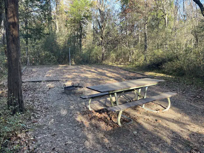
- All sites are equipped with a picnic table, fire ring with grill, and lantern pole.
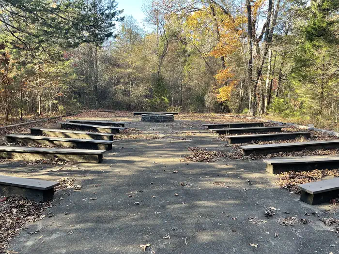
- There is an ampitheatre-style area in the campground that is available first-come, first-serve.
- Chickamauga Battlefield Visitor Center is 1.5 miles away by car and about 0.45 miles on foot.
Natural Features
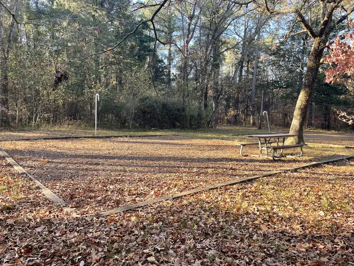
Chickamauga Battlefield Group Campground offers tree-sheltered, flat tent sites. The campground is surrounded by a hardwood decidious forest. With over 9,000 acres of preserved land, Chickamauga and Chattanooga National Military Park has many native plants and animals which call the park home.
Nearby Attractions
- Chickamauga Battlefield Visitor Center is located less than 2 miles from the camping area by vehicle and 0.45 miles by foot.
- Again, these campsites are only available to organized youth groups and as such are not open to the public. There are a number of public and private campgrounds in the surrounding area.
Charges & Cancellations
The facts
- 9 bookable sites
- Up to 50 people per site
- Loops: Chickamauga Battlefield
Site types
- 9 Group Tent Only Area Nonelectric
Amenities
- Water hookups
- Campfires allowed
Not recorded upstream: electric hookups, sewer hookups, fire pits, picnic tables, grills, shade, pets allowed.
9 campsites at Chickamauga Battlefield Group Campground
| Site | Loop | Type | Entry | Surface | Max rig | People | |
|---|---|---|---|---|---|---|---|
| Site 1 | Chickamauga Battlefield | Group Tent Only Area Nonelectric | — | — | — | 50 | |
| Site 2 | Chickamauga Battlefield | Group Tent Only Area Nonelectric | — | — | — | 20 | |
| Site 3 | Chickamauga Battlefield | Group Tent Only Area Nonelectric | — | — | — | 40 | |
| Site 4 | Chickamauga Battlefield | Group Tent Only Area Nonelectric | — | — | — | 45 | |
| Site 5 | Chickamauga Battlefield | Group Tent Only Area Nonelectric | — | — | — | 30 | |
| Site 6 | Chickamauga Battlefield | Group Tent Only Area Nonelectric | — | — | — | 20 | |
| Site 7 | Chickamauga Battlefield | Group Tent Only Area Nonelectric | — | — | — | 20 | |
| Site 8 | Chickamauga Battlefield | Group Tent Only Area Nonelectric | — | — | — | 10 | |
| Site 9 | Chickamauga Battlefield | Group Tent Only Area Nonelectric | — | — | — | 10 |
Getting there
From Chickamauga Battlefield Visitor Center, turn right (south) onto Lafayette Road. Travel 1.5 miles and turn right onto Dyer Road. You will see Brotherton Cabin at this intersection. At the first stop sign, turn right onto Glenn-Kelly Road. Travel 0.5 miles, passing a triangular intersection on your left. Turn left at the next roadway, South Post. Enter through the gate, making sure to close it behind you. Drive down this road and the camping loop will be on your right. Campsites are located around this loop road and each site is marked with a numbered post.
34.92828, -85.26414 · 34°55'41.8"N 85°15'50.9"W
Typical weather
Typically 89°F in Jul, down to 51°F in Jan.
| Jan | Feb | Mar | Apr | May | Jun | Jul | Aug | Sep | Oct | Nov | Dec | |
|---|---|---|---|---|---|---|---|---|---|---|---|---|
| High °F | 51 | 56 | 64 | 73 | 80 | 86 | 89 | 89 | 84 | 75 | 62 | 53 |
| Low °F | 29 | 32 | 37 | 45 | 54 | 63 | 66 | 66 | 59 | 47 | 35 | 31 |
| Precip in | 5.6 | 5.1 | 5.0 | 4.7 | 4.6 | 4.2 | 5.1 | 4.5 | 4.2 | 3.6 | 4.4 | 5.4 |
1991–2020 averages from the nearest NOAA station, 0.7 mi away — not measured at the facility itself, and elevation can make a real difference over that distance.
Map
Fees and stay limits
Current camping rate is $20 per night for each site.
From Recreation.gov, which is not always current. The operator's own page is the authority on what you will be charged.
More photos
Member photos
Common questions about Chickamauga Battlefield Group Campground
- Can you reserve a site at Chickamauga Battlefield Group Campground?
- Yes, Chickamauga Battlefield Group Campground is reservable through Recreation.gov.
- How many campsites does Chickamauga Battlefield Group Campground have?
- 9 sites.
- Does Chickamauga Battlefield Group Campground have hookups?
- Water.
- Are campfires allowed at Chickamauga Battlefield Group Campground?
- Campfires are allowed at Chickamauga Battlefield Group Campground. Check for a current fire restriction before you go.
Camping near Chickamauga Battlefield Group Campground
- Pocket Campground 25.9 mi · Campground · we watch it
- Pocket Picnic Shelter 25.9 mi · Campground · we watch it
- Lake Conasauga Overflow Campground 34.7 mi · Campground · we watch it
- Chickamauga Battlefield Visitor Center 0.9 mi · Facility
- Lookout Mountain Battlefield Visitor Center 7.2 mi · Facility
- John's Mountain Overlook 23.1 mi · Facility
- Keown Falls Picnic Area and Trailhead 23.9 mi · Facility
- Dry Creek Equestrian Trailhead 25.3 mi · Facility
- Conasauga Ranger District 25.9 mi · Facility
- Gilbert Grosvenor Visitor Center 31.1 mi · Facility
- Hickey Gap Campground 33.6 mi · Campground
- Ball Field Dispersed Camping Area 34.7 mi · Facility
Contact
- Phone 706-866-9241
- Email chch_information@nps.gov
- Book Recreation.gov
Recreation.gov last updated this record on 2026-03-11.
Facility information and photographs from Recreation.gov (RIDB). SpotOpened is not affiliated with Recreation.gov or any federal agency.
Comments