Reef Townsite Group Area
Campground · Arizona · 1 bookable site ·
Managed by the USDA Forest Service
Coronado National Forest (NF) · Open Access
- 1
- Bookable site
- up to 50
- People per site
- 7,165 ft
- Elevation

Overview
This high-mountain group campground and day use area is located on a site that was once occupied by the old mining town of Reef. Many relics of Reef's mining history, including the remains of the town's old water system, are still visible in and around the campground. Groups of up to 50 people can enjoy walking an interpretive history trail, hiking, horseback riding and watching wildlife in this cool mountain setting.Recreation
Reef Townsite Loop Trail, an interpretive trail that highlights the mining history of this area and showcases beautiful views, begins and ends at the northeastern edge of the campground.The national forest has a variety of hiking and mountain biking trails for those who wish to leave the facility for a day trip.
Facilities
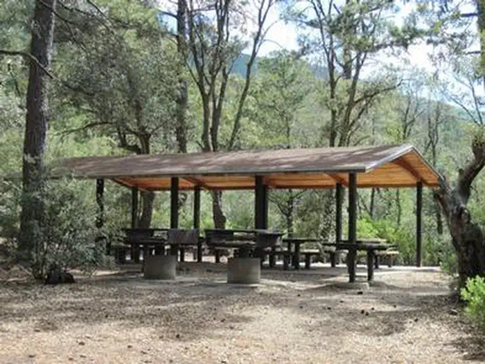
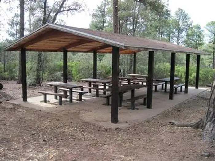
Reef Townsite can accommodate one group of up to 50 people at a time. Facilities include a picnic shelter that contains six picnic tables, two large group barbecue grills and two food preparation tables, as well as toilets, a parking area and a large shaded area for tents.Natural Features
This site rests on the "Reef" rock formations in the in the Huachuca Mountains. At an elevation of 7,200 feet, it provides a cool respite from the heat of surrounding lower deserts in summer.The Coronado National Forest covers 1.78 million acres of southeastern Arizona and southwestern New Mexico. Elevations range from 3,000 to 10,720 feet in 12 widely scattered mountain ranges, or "sky islands," that rise dramatically from the desert floor, supporting biologically diverse plant communities.
The facts
- Season: Spring – Winter — USDA Forest Service, Aug 24, 2026
- 1 bookable site
- Up to 50 people per site
- Loops: REEF TOWNSITE GROUP AREA
Site types
- 1 Group Standard Area Nonelectric
Amenities
- Campfires allowed
- Picnic tables
- Grills
- Shade
- Pets allowed
Not recorded upstream: electric hookups, water hookups, sewer hookups, fire pits.
1 campsite at Reef Townsite Group Area
| Site | Loop | Type | Entry | Surface | Max rig | People | |
|---|---|---|---|---|---|---|---|
| 1 | REEF TOWNSITE GROUP AREA | Group Standard Area Nonelectric | — | — | — | 50 | 🐾 |
Getting there
From Tucson, Arizona, drive east on I-10 to exit 302 to State Route 90. Drive south 25 miles through Sierra Vista. Proceed 8 miles south of Sierra Vista on State Route 92 and turn west onto Carr Canyon Road/Forest Road 368.
Forest Road 368 is a narrow gravel road with steep mountain grades, tight switchbacks and recomended for vehicles with good clearance. Contact Sierra Vista Ranger District Office if you have questions or want to know current conditions.
31.42917, -110.29056 · 31°25'45.0"N 110°17'26.0"W
Typical weather
| Jan | Feb | Mar | Apr | May | Jun | Jul | Aug | Sep | Oct | Nov | Dec | |
|---|---|---|---|---|---|---|---|---|---|---|---|---|
| High °F | — | — | — | — | — | — | — | — | — | — | — | — |
| Low °F | — | — | — | — | — | — | — | — | — | — | — | — |
| Precip in | 1.3 | 0.8 | 0.5 | 0.3 | 0.2 | 0.9 | 3.9 | 3.8 | 1.7 | 0.9 | 0.7 | 1.2 |
1991–2020 averages from the nearest NOAA station, 4.1 mi away — not measured at the facility itself, and elevation can make a real difference over that distance.
Map
More photos
Member photos
Common questions about Reef Townsite Group Area
- Can you reserve a site at Reef Townsite Group Area?
- Yes, Reef Townsite Group Area is reservable through Recreation.gov.
- How many campsites does Reef Townsite Group Area have?
- 1 site.
- Are pets allowed at Reef Townsite Group Area?
- Yes, pets are allowed at Reef Townsite Group Area.
- Are campfires allowed at Reef Townsite Group Area?
- Campfires are allowed at Reef Townsite Group Area. Check for a current fire restriction before you go.
Also listed by
Reef Townsite Group Area also appears in other federal recreation data. Facts below are matched by name and location, not confirmed by Reef Townsite Group Area's operator.
USDA Forest Service — data as of Aug 24, 2026
- Single site: $15. With Golden Age/Access or Interagency Senior/Access pass $7.50. Payable with cash or check.
Restrictions:
- Trailers limited to 12 feet and less. Longer trailers and motor homes cannot negotiate the switchbacks on Carr Canyon Road. No utility hookups. Pets need to beon a leash at all times. Pack and saddle stock are not permitted in campground or picnic area. Properly licensed motorbikes may be used only
Camping near Reef Townsite Group Area
- Rock Bluff Group Site 9.6 mi · Campground · we watch it
- Canelo Ranger Office 15.7 mi · Campground · we watch it
- Canelo Ranger Residence 15.8 mi · Campground · we watch it
- Ramsey Vista Campground 0.8 mi · Campground
- Coronado National Memorial Visitor Center 6.1 mi · Facility
- Lakeview Campground 9.5 mi · Campground
- Hereford Trailhead 10.7 mi · Facility
- Murray Springs Clovis Site 11.7 mi · Facility
- San Pedro House 12.1 mi · Facility
- Fairbank Historic Townsite 21.2 mi · Facility
- Presidio Santa Cruz de Terrenate 22.8 mi · Facility
- Historic Empire Ranch 32.9 mi · Facility
Contact
- Book Recreation.gov
Recreation.gov last updated this record on 2026-02-25.
Facility information and photographs from Recreation.gov (RIDB). SpotOpened is not affiliated with Recreation.gov or any federal agency.
Comments